Fillable Printable Planning Application Form - California
Fillable Printable Planning Application Form - California
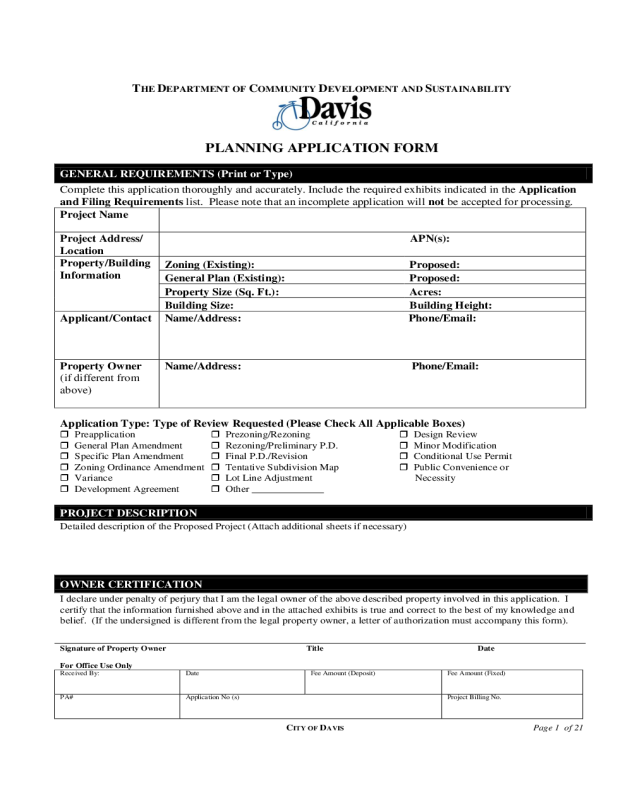
Planning Application Form - California

CITY OF DAVIS Page 1 of 21
THE DEPARTMENT OF COMMUNITY DEVELOPMENT AND SUSTAINABILITY
PLANNING APPLICATION FORM
GENERAL REQUIREMENTS (Print or Type)
Complete this application thoroughly and accurately. Include the required exhibits indicated in the Application
and Filing Requirements list. Please note that an incomplete application will not be accepted for processing.
Project Name
Project Address/
Location
APN(s):
Property/Building
Information
Zoning (Existing):
Proposed:
General Plan (Existing):
Proposed:
Property Size (Sq. Ft.):
Acres:
Building Size:
Building Height:
Applicant/Contact
Name/Address: Phone/Email:
Property Owner
(if different from
above)
Name/Address: Phone/Email:
Application Type: Type of Review Requested (Please Check All Applicable Boxes)
Preapplication Prezoning/Rezoning Design Review
General Plan Amendment Rezoning/Preliminary P.D. Minor Modification
Specific Plan Amendment Final P.D./Revision Conditional Use Permit
Zoning Ordinance Amendment Tentative Subdivision Map Public Convenience or
Variance Lot Line Adjustment Necessity
Development Agreement Other
PROJECT DESCRIPTION
Detailed description of the Proposed Project (Attach additional sheets if necessary)
OWNER CERTIFICATION
I declare under penalty of perjury that I am the legal owner of the above described property involved in this application. I
certify that the information furnished above and in the attached exhibits is true and correct to the best of my knowledge and
belief. (If the undersigned is different from the legal property owner, a letter of authorization must accompany this form).
Signature of Property Owner Title Date
For Office Use Only
Received By:
Date
Fee Amount (Deposit)
Fee Amount (Fixed)
PA#
Application No (s)
Project Billing No.

CITY OF DAVIS Page 2 of 21
THE DEPARTMENT OF COMMUNITY DEVELOPMENT AND SUSTAINABILITY
23 Russell Boulevard, Suite 2 - Davis, CA 95616
PH: 530/757-5610; FAX: 530/757-5600; TDD: 530/757-5666
APPLICATION PROCEDURE AND FILING REQUIREMENTS
SECTION 1: Application Procedure & General Filing Requirements
A. Preapplication Review
It is recommended for projects of a more complex nature, that the applicant submit a Preapplication proposal prior to
submission of the formal application. This will allow the Planning, Building and Public Works staff to review the
request and provide input on potential environmental concerns, zoning and engineering requirements, and specific
traffic, site planning, landscaping, and building design criteria. This early review and input by staff should save the
applicant possible delay and expensive plan revisions later in the process.
B. Initial Submittal – Due when initial application is filed with the City
(Note: Some items listed below may not be required based on type of application, Refer to Section 3, Table 1)
1. Completed Planning Application Form.
2. Applicant Narrative / Justification Statement.
3. Environmental Information Form (may not be required for minor applications).
4. Filing Fees and Fee Agreement.
5. Twelve sets of the Project Development Review Information (if applicable, see Section 3, Table 1, Part
2) to be reviewed by staff for completeness and accuracy. Fewer sets may be acceptable for minor
applications.
6. One materials / color board.
7. One set of 8½ x 11”reductions of all plans.
8. One set of colored elevations.
9. Other: Depending on the nature of the project, additional descriptive materials may be required such as
models, sight line studies, computer overlay graphics, and/or a streetscape perspective.
10. Electronic copy of application, plans and color exhibits in PDF or other acceptable image format.
C. Final Submittal – Due once application has been determined complete and ready for further
processing
(Note: Some items listed below may not be required based on type of application. Refer to Section 3, Table 1, i.e. final
submittal may not be required for minor applications)
1. Twelve sets of Project Development Review Information (if applicable, see Section 3, Table 1, Part 2)
2. A revised set of colored plans to include: a detailed site plan, conceptual landscape plan, illustrative
building elevations, and any necessary cross-sections.
3. A revised building materials sample board in an 8½ x 11” format, as needed.

CITY OF DAVIS Page 3 of 21
4. Photographs of the existing site (dependent on scope of project) taken from locations as shown in the
attached example. The submitted photos are encouraged to be in digital form (JPEG files, formatted for the
PC). Printed photos mounted on 8½ x 11” paper are acceptable and may include a photographic location
map, as needed.
5. A revised set of 8½ x 11” reduced plans.
6. Streetscape perspective. Required for all residential (new construction) applications. May be required for
other projects.
7. A revised electronic copy of application, plans and color exhibits in PDF or other acceptable image
format
SECTION 2: Plan Preparation Guidelines
1. All plans shall be drawn on uniform sheets of 24” x 36” or 30” x 42”. However, for minor application
reviews such as minor modifications, plans may be 8½ x 11” in size as long as all necessary information has
been provided and plans are clearly legible.
2. All site and landscape plans shall be drawn to an engineering scale of 1”=20’; 1”=30’; 1”=40’; or 1”=50’
with the scale clearly labeled.
3. All elevations shall be drawn to an architectural scale no smaller than ¼”=1’.
4. All required plans shall be collated and stapled together into development package sets and shall be folded
to the following specifications. Each set shall be:
a) folded lengthwise in half with the text inside
b) fold the two opposite edges back over to meet the spine of the original fold
c) then, beginning on one long end fold in 2 or 3 sections as necessary to result in a rectangular set
approximately 8½ x 11” in size (accordion style).
Colored plans shall be rolled rather than folded.
* It should be noted that additional sets of plans may be required for distribution.
CITY OF DAVIS Page 4 of 21
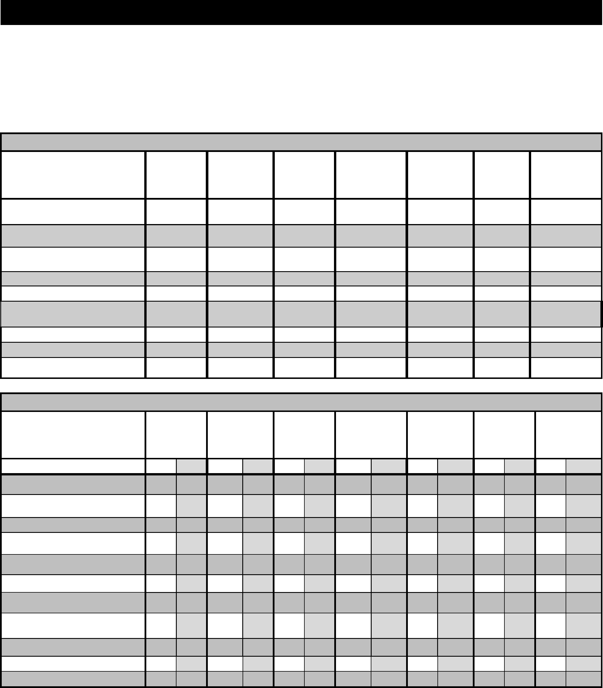
SECTION 3: Table 1 – Application Submittal Requirements
The following information is required to process planning applications. An “X” in a cell means the information is required for
that particular application. Applicants are responsible for providing a complete and accurate submittal package which will
allow the city to evaluate the application. The initial submittal requirements are due when the application is filed with the City
(at filing deadline). The final submittal requirements are due once the application has been determined complete and ready for
further processing. These plans will then be used to prepare final conditions and will be distributed to Planning
Commission/City Council. Staff will notify project applicant when the final submittal package is due.
General Project Information
SUBMITTAL
REQUIREMENTS
General /
Specific Plan
Amendment
Rezone &
Preliminary
PD
Final PD &
Revision
Tentative Map /
Other Map
Applications
Design
Review
Conditional
Use Permit
Variance &
Minor
Modification
Completed Application Form
(Signed by the Property Owner)
X
X
X
X
X
X
X
Applicant Narrative /
Justification
X
X
X
X
X
X
X
Environmental Information
Form
X
X
X
X
X
X
X
Signed Fee Agreement
X
X
X
X
X
X
X
Fee
X
X
X
X
X
X
X
Electronic copy of application,
Plans & color exhibits
X
X
X
X
X
X
X
Title Report
X
X
X
X
X
X
X
Legal Description
X
X
X
X
X
X
X
Contextual Map
X
X
X
X
X
X*
X*
Project Development Review Information
SUBMITTAL
REQUIREMENTS
General /
Specific Plan
Amendment
Rezone &
Preliminary
PD
Final PD &
Revision
Tentative Map /
Other Map
Applications
Design
Review
Conditional
Use Permit
Variance &
Minor
Modification
INITIAL/FINAL
I
F
I
F
I
F
I
F
I
F
I
F
I
F
Site Plan (12 sets) if applicable
X
X
X
X
X
X
X
X
X
X
X*
X*
X*
X*
Building Elevations/ Floor Plans
(12 sets)
X
X
X
X
X*
X*
X*
X*
Materials/Color Board (1 set)
X
X
X
X
X*
X*
Conceptual Landscape Plan (12
sets)
X
X
X
X
X*
X*
Parking Lot Shading Plan (12
sets)
X
X
X
X
X*
X*
Conceptual Grading Plan
X
X
X
X
X
X
Tentative Map (12 sets)
X#
X#
X
X
8 ½” x 11” Reductions of all
Plans (1 set)
X
X
X
X
X
X
X
Colored Landscape Plans (1 set)
X
X
X*
Colored Elevations (1 set)
X
X
X
X
X
X
Streetscape Perspective
X
X
X
* Required number of sets are dependent upon nature of the application. Those which are minor in nature, may only be required to
submit 4-sets of plans and may not be required to submit material samples. Additionally, at the discretion of the Department of
Community Development and Sustainability, minor projects such as minor modification may only require in 8½ x 11” size plans.
# If a tentative map is involved, please submit additional copies with the package.

CITY OF DAVIS Page 5 of 21
SECTION 4: Explanation of Matrix Information
: Plan Preparation
Application Form, Fees, and Environmental Information Form. Only one form is required for all applications;
do not submit separate applications for the different requested actions. Fees are according to entitlement.
Applicant Narrative/Justification. This is a written narrative provided by the project proponent explaining the
application request, project description and goals, and justification statement if any deviation from approved or
standard code is requested. In the case of a request for a General Plan amendment, the applicant should provide
written justification as to why and how a change in the approved General Plan would provide benefit to the
community.
Outreach Summary. The City encourages early consultation with adjacent neighbors, particularly if they may be
impacted by a proposed project. Provide information on outreach to potentially affected parties, including: who has
been contacted; by what means (preferably in person); what comments and concerns were received; and what has
been done to address, or the reasons for not addressing, the comments and concerns.
Title Report. This is required unless specifically waived by the Public Works Staff.
Legal Description. This can be obtained from the Title Report. Lot Line Adjustment/Mergers require descriptions of
both the existing and proposed properties. Check with Staff for other requirements.
Contextual Map. This is a map that shows the location of the site and the relationship of the proposed project to
existing surrounding properties, buildings, and site features. This map shall indicate the proposed project site plan,
all parcel lines and streets, location and use of structures, adjacent access and circulation, and existing zoning and
land use within an approximately 300-foot radius. Aerial photographs may be used if features are properly labeled.
Site Plans. The following information is required to be included on all plans in order for the plan to be considered
complete. Information may be provided on more than one page for legibility, if necessary.
Name, address, and daytime phone number of the applicant and the author of the plan.
Date of preparation of plan, scale, and north arrow. North must be at the top of the site plan. A small
vicinity map shall be located in the upper right hand corner of the plan, or attached as a separate map, with
the project site located in relation to major streets and landmarks.
Property lines and lot dimensions, square footage, Assessor’s Parcel Number, address and APN’s of the
adjacent properties.
Existing and proposed easements. State the purpose of the easement (i.e., access, PUE, etc.) If requesting
abandonment of an easement, include a statement on the plan which contains the legal description of the
easement, plus the County Recorder’s book and Page numbers, date easement was granted, who granted the
easement, for what purpose the easement was granted and whether the easement has been used.
Drainage structures and direction of surface flow (if not included on a conceptual grading plan).
Locations of all buildings and other structures, including existing fencing, both on the property and within
200 feet of the site.
Dimensioned locations of:
Street dedications and improvements (existing and proposed), including overhead utilities
Access, for vehicular, bicycles, and pedestrian, showing service area and points of ingress and egress.
Off street parking and loading or outdoor storage areas showing location, number and typical
dimension of spaces and wheel stop locations.
All street improvements, driveways and parking on adjacent and across-the-street properties within 200
feet of the site.
Any existing or planned median islands within 200 feet of the site.
All structures/ buildings existing or proposed on site; clearly indicating size of structure(s), setbacks
from property lines, yard areas, and distances between buildings/structures.
Landscape areas including designated open space, landscape planters, islands, tree wells, etc.
CITY OF DAVIS Page 6 of 21
Building accessory structure and mechanical equipment locations, including pavement/sidewalks,
trellises, light standards, trash enclosures, transformers, and monument signs, including dimensioned
setbacks (front, rear, sides)
Location, height and materials of all walls.
All property proposed for public use. Note size of all property to be dedicated, conveyed and /or
reserved for streets, open space and affordable housing program dedicated land.
Open space use must be described (i.e., yard, greenbelt, park, drainage, etc.) and a statement disclosing
the means whereby such open space provided for public use shall be established and maintained. For
residential projects, a separate exhibit showing usable open space locations and calculations shall be
included.
Parking areas shall be clearly labeled. Include a summary table of the number of spaces, accessible and
van-accessible spaces and ramps, dimensions of spaces and aisles, and a comparison of required and
provided spaces.
Plans must also show location of bicycle racks, and path of travel from the street to the bicycle racks. A
separate bicycle parking exhibit is suggested for commercial/apartment projects.
Building Elevations
Illustrative elevations of all sides of buildings and structures. “Illustrative” building elevations means drawn
with shadows to give depth with people, cars or trees for scale. Do not cover the elevation with trees, cars,
or people – place them behind or on the side.
Illustrative elevations of all walls and/or fences.
Illustrative cross sections and enlargements or architectural elements or details as needed.
All exterior building materials shall be clearly labeled on each sheet of elevations. These shall include notes
on all design details such as building materials, roofing materials, trim and building colors, etc. Design
details such as lighting fixtures, bicycle racks, paving materials, directory structures, trellis and awnings,
fencing, etc. shall be clearly described and drawn.
Floor Plans. All floors, including labeled use of each room (bedroom, kitchen, office, warehouse, etc.) Dimensions
of all exterior walls, doors, windows and room sizes.
Materials Board. Exhibit containing actual samples of roof, building, paint, awning, and window materials.
Conceptual Landscape Plans
All proposed and existing structures and improvements as shown on the detailed site plan; however, all
dimensions shall be excluded. Show roof outlines, including eave overhang.
Conceptual location of all plants and a planting legend which identifies such things as:
Trees, shrubs, and ground cover areas or other softscape elements. Indicate the intended function of
plants (i.e. street tree, accent tree, canopy shade tree, parking lot tree, screening hedge, etc.)
Plant legend (schedule) shall identify type of plant with genus and common names, size of plants
initially and at maximum growth, and corresponding symbol identification for the plan.
Include description of open space areas, (i.e. common area, tot lot, barbeque areas, pool/spas, recreation
buildings, sports courts, etc…) calculation of landscape area or useable open space.
Existing trees on site or other plants proposed for removal and/or retention. Plants to be deleted shall be
marked with an ‘X’ across the trunk or plant base.
Information on identified significant trees (Section 37.04.040) including: species, size, and condition, as
determined by an arborist. Details of proposed construction activity within the root zone, including grading
trenching, building construction, utility work, staging, storage and parking, both during construction and
upon project completion.
Plazas, sidewalks or other hardscape elements, such as special paving materials or rockscape.
CITY OF DAVIS Page 7 of 21
Private and public sidewalks, paths or greenbelts.
Primary and secondary project entry points and their treatment (textured paving, accent planting, entry
walls, and/or monument signs).
Parking Lot Shading Plan. This plan is to be separate from the landscape plan. (See Parking Lot Shading
Guidelines handout for examples and approved parking lot tree species)
The plan should clearly show all surfaced areas included in the calculation. Parking areas included should
be shaded. A surface area square footage amount shall be indicated.
Tree canopies drawn to scale representing the appropriate canopy size at 15 years and the percentage of
shade for each tree clearly indicated using shading or other graphic representation.
Provide a shade calculation table identifying the quantity and type of trees used and the corresponding
percentage of shade credited to each tree.
Conceptual Grading Plan.
Proposed items shall be identified with solid lines and existing features with short dashes or screened
Proposed grading, structures, curbs, walls (ht), sidewalk gutters, drainage structures, swales, etc. The plan
shall include spot elevations, gradients, contours, details, cross sections, flow arrows, etc.
Existing features within 200 feet beyond site boundaries; natural ground (contours), trees, structures (pad
and floor elevations), drainage courses, streets, etc.
Structures, footprints, pad and floor elevations, retaining walls, etc.
Easements, property lines and rights of way
Earthwork quantities (borrow and disposal areas)
Existing and proposed sewers
Drainage and flood control facilities (size, type, etc.)
Cross sections at all site boundaries to scale, showing existing and proposed grading, cut and fall, wall
heights, and elevation differences. Sections should extend through building pads and streets.
Shade pavement and slopes 3:1 or steeper
Tentative Map. See Supplemental Requirements for Tentative Map Applications handout.
Reduced Plans. A set of site plans reduced to 8½ x 11” paper and legible for photocopying. For Rezoning, Tentative
Maps, and Planned Developments the reductions must be PMT reductions.
Colored Landscape Plans. Plans should be colored to clearly illustrate locations and percentage of pavement,
building areas as well as amount and type of landscape.
Electronic copy of application, plans and color exhibits in PDF or other acceptable image format.
Colored Elevations. Elevations should be colored to represent as closely as possible the colors and materials proposed.

CITY OF DAVIS Page 8 of 21
RULES PERTAINING TO YOUR OBLIGATION TO PAY
THE CITY OF DAVIS
FOR THE TOTAL COST OF PROCESSING
AN APPLICATION FOR A LAND USE ENTITLEMENT
PLEASE READ THE FOLLOWING CAREFULLY. IT EXPLAINS YOUR LEGAL
OBLIGATION TO PAY THE FULL COST OF PROCESSING YOUR LAND USE APPLICATION
WITH THE CITY OF DAVIS.
GENERAL
1. The City Council of the City of Davis has adopted a policy which requires that you, as an
applicant for a land use entitlement from the City, pay all costs and fees associated with the processing
of your application.
2. A land use entitlement is the grant by the City of Davis, under its municipal powers, which
allows you to use your property in a certain way as defined by the ordinances, resolutions, rules and
regulations of the City and of State law. Some examples of land use entitlements are: a rezoning, a
conditional use permit, and a subdivision map.
3. The policy provides that all costs associated with the processing of your application are to
be paid by you whether or not your application is ultimately approved.
SPECIFIC REQUIREMENTS AND OBLIGATIONS
1. In order for the Community Development and Sustainability Department (the
"Department") to commence the processing of your application, you must have on file, in addition to
the application itself, a signed copy of the form entitled AGREEMENT TO PAY THE CITY OF
DAVIS THE TOTAL COSTS INCURRED IN CONNECTION WITH THE PROCESSING OFAN
APPLICATION FOR A LAND USE ENTITLEMENT.
A copy of the Agreement for your signature is attached.
2. The Agreement places upon you certain legal obligations. If you have any questions
concerning it, you should consult with an attorney of your choice. Neither the Department nor the City
Attorney can provide you with legal advice.
3. The purpose of the Agreement is for the City to recover the actual costs associated with
your application. These costs include, but are not limited to, City staff time, outside professional
services, outside agency filing fees, property inspections, and similar matters.
4. The amount to be reimbursed for any particular activity (i.e., staff review) is set forth in the
Master Fee Schedule adopted by the City Council from time to time. You are entitled to a copy of the
schedule upon request. Fees are subject to increase while your application is pending.
5. Some applications require only the payment of a fixed fee. Others are processed on an
hourly rate basis. For those applications processed on an hourly basis, a deposit is required as set forth
in the Master Fee Schedule. From time to time you may be required to make additional deposits as
determined by the Department. A failure to make any required deposit within the time specified by the
Department will result in your application being put "on hold" until the deposit is made. Your
application will not be considered by the City Planning Commission, the City Council, or any other
CITY OF DAVIS Page 9 of 21
decision-making body until all required deposit(s) have been made. If a deposit is not made within 10
days after you receive a final demand to make the deposit, your application will be deemed denied.
6. You are entitled to know the approximate costs incurred to date during the application
process by requesting that information from the Department. If you decide to withdraw your
application at any time you will receive a reimbursement of deposited money only to the extent that
your deposit exceeds the total amount of the obligation you have incurred to that point. You are not
entitled to a reimbursement for any services actually provided up to the time you withdraw your
application. Fixed fee application refunds are subject to the Department of Community Development
and Sustainability Refund Policy contained in the Planning Division Fee Schedule.
7. If, after a determination is made on your application, and all follow-up matters pertaining to
your application have been completed and you have money on deposit that exceeds the amount owed
under the Agreement, you will receive a refund.
8. The Agreement specifically provides that if the City is required to maintain legal action to
enforce it, you will be required to pay attorney fees incurred by the City. [Under State law if you win
such a legal action the City must pay your attorney fees.] The Agreement also provides that the City
may place a lien on the property to which your application pertains for any unpaid fees, including
attorney fees.
9. The Agreement also provides that you defend and "hold harmless" the City in the event
it is sued for approving your application. However, you may choose to have the City rescind any land
use entitlement granted to you rather than defend the City.
10. At any time during the application process you may request that the City, in writing,
provide its interpretation of the Agreement if there is a dispute between you and the Department
regarding its terms or application.
11. A copy of this document will be incorporated into the Agreement by reference. Below
is an acknowledgment which you must sign that shows that you have read and understand this
document.
IT IS THE POLICY OF THE CITY OF DAVIS TO DEAL FAIRLY AND IMPARTIALLY WITH
EACH APPLICANT FOR A LAND USE ENTITLEMENT. TO AVOID ANY DELAYS OR
MISUNDERSTANDINGS, YOU ARE ENCOURAGED TO CONSULT WITH THE DEPARTMENT
OF COMMUNITY DEVELOPMENT AND SUSTAINABILITY ON ANY MATTER OF
CONCERN.

CITY OF DAVIS Page 10 of 21
ACKNOWLEDGMENT
I, , AN APPLICANT FOR A LAND USE ENTITLEMENT
FROM THE CITY OF DAVIS, ACKNOWLEDGE THAT:
1. I HAVE RECEIVED AND READ A COPY OF THIS DOCUMENT.
2. I UNDERSTAND THE CONTENTS OF THIS DOCUMENT.
3. I UNDERSTAND THAT I WILL BE REQUIRED, AS PART OF THE PROCESSING OF MY
LAND USE APPLICATION, TO ENTER INTO A LEGALLY BINDING AGREEMENT TO
REIMBURSE THE CITY OF DAVIS FOR COSTS INCURRED IN THAT PROCESSING.
Dated:
Signature of Applicant
Signature of Property Owner,
(if different than the Applicant)

CITY OF DAVIS Page 11 of 21
AGREEMENT TO PAY THE CITY OF DAVIS
THE TOTAL COSTS INCURRED
IN CONNECTION WITH THE PROCESSING OF
AN APPLICATION FOR A LAND USE ENTITLEMENT
THIS IS AN AGREEMENT between ("Applicant") and the City
of Davis, a municipal corporation ("City"). It is effective on the date that an application for a land use
entitlement is accepted for processing by the City. (For purposes of this Agreement, the term
"Applicant" includes a) the property owner, and/or b) any authorized agent of the property owner for
whose property the entitlement is sought).
THIS AGREEMENT is made with reference to the following facts, among others:
A. The application pertains to real property commonly identified as Assessor's Parcel(s) No(s)
, with a street address of ("the
property").
B. Applicant has filed, and the City, through its Department of Community Development and
Sustainability, has accepted for processing, an application for a land use entitlement for the property.
(The term "application" includes a pre-application if the pre-application process is used). The
Application number is (the "Application").
C. The City has adopted a program which requires an applicant for a land use entitlement to pay all
costs associated with the processing of an application.
D. Applicant agrees to pay such costs as herein provided.
E. This Agreement includes a document entitled RULES PERTAINING TO YOUR
OBLIGATION TO PAY THE CITY OF DAVIS FOR THE TOTAL COST OF PROCESSING AN
APPLICATION FOR A LAND USE ENTITLEMENT. A copy of that document is attached hereto
and incorporated by this reference. Applicant, by his/her/its initials, states that Applicant has read and
understood the matters set forth in that document.
Initials
WHEREFORE, THE PARTIES AGREE AS FOLLOWS:
Applicant agrees to pay the City all costs incurred, both direct and indirect, including State-mandated costs,
associated with the review and processing of the Application for a land use entitlement with respect to the
property.
The obligation set forth in section 1 applies even if the Application is withdrawn or is not approved.
The term "costs" includes all items within the scope of the City’s adopted Master Fee Schedule, as well as the
cost of retaining professional consultants to prepare environmental documentation, provide planning,
engineering, building inspection, and legal services, and to perform other functions related to review and
processing of the application. (A copy of the current fee schedule may be obtained from the Department of
Community Development and Sustainability).
Applicant understands that one or more payments will be required to cover the costs described above at such
time(s) as requested by the Community Development and Sustainability Director. Certain applications require