Fillable Printable Special Warranty Deed - Arkansas
Fillable Printable Special Warranty Deed - Arkansas

Special Warranty Deed - Arkansas
Prepared by:
C.
Tad Bohannon
Wright,
Lindsey
& Jennings
LLP
200 West Capitol
Avenue, Suite
2300
Little
Rock, Arkatsas
12201
I certify under
penalty
of
false swearing
that at
least the
legally
correct
amount of
documentary stamps
have
been
placed
on
this instrument.
(If
none shown,
exempt
or no consideration
paid.)
Signature
of Grantee
or Agent:
Grantee's
Address:
SPECIAL
WARRANTY
DEED
WITH
POSSIBILITY
OF
REVERTER
CENTRAL
ARKANSAS
WATER,
a consolidated
water
association
created
and
existing
under
the Consolidated
'Waterworks
Authorization
Act,
Act 982
of the 83'd
General
Assembly
of
the state of
Arkansas
("Grantor"),
by
its Chief
Executive
Officer,
duly authorized
by
proper resolution
of the
Board of Commissioners
of Central
Arkansas Water,
for
and
in
consideration
of the sum
of
$10.00
and other
valuable
consideration
in hand
paid
by
the CITY
OF
LITTLE
ROCK,
ARKANSAS,
a duly
incorporated
city of
the
first class under
the
laws of
the State
of
Arkansas
("Grantee"),
the
receipt
of which
is
hereby acknowledged,
does
hereby
grant,
bargain, sell
and
convey unto
Grantee,
subject
to the
limitations,
restrictions,
easements
and
leservations
hereinafter
mentioned,
the
real
property in Pulaski
County,
Arkansas
described
on
Exhibit
A
attached
hereto
(the
"Property").
This conveyance
is made subject
to an easement
retained by
Grantor
over the
entire
area
of the
Proper-ty
to be used by
Grantor,
and
its employees,
contractors,
and
agents,
for
(i) pulposes
of owning
and
operating
a
"consolidated
waterworks
system"
as such
terrn
is
defined
in the
Consolidated
'Waterworks
Authorization
Act
("Water
System
lJses"),
and
(ii) pulposes
necessarily
incidental
to
'Water
System
lJses,
including, without
limitation,
creatiotl
or
maintenance
of
a
"buffer"
or
other
protective
zone
for
the
protection
of
Lake
Maumelle and
its
dam
andlor
pump
station
facilities,
staging of
materials
for construction
projects
related
to Water
System
lJses,
maintenance,
repair or expansion
of
the dam
creating
Lake
Maumelle,
or any
other
uses
deemed
necessary by
Grantor
for Water
System
Uses
(collectively,
all of
the
purposes
set
forth
in
this
paragraph
shall be
referred to
herein as
"Access
Rights")'
Whenever
Grantor
desires
to exercise
its Access
Rights, Grantor
shall
provide
Grantee
with
at
least
six
(6)
months written
notice of
its intent to
utilize the
Property and shall,
if
possible, identify that
portion
of the
Property
that will
be utilized
by
Grantor
if not all of the
Property will be
utilized, and
shall
provide
an
estimation
of the
time
period
of
use, but
in no
event
shall such
estimation
be binding
upon
Grantor.
Notwithstanding
the
prior
sentence,
in the
event of
an emergency,
Grantor
may
enter and
exercise
its
Access
Rights with
prior
notice
to
Grantee.
This conveyance
is
also
made with
the
express
limitation
that the
Property shall
be used
by
Grantee solely
for recreational
activities
such as
playing
fîelds,
jogging,
hiking,
picnicking,
fishing, biking
and such
other
passive, low
impact, non-motorized
activtties
that are consistent
83450
I
with
protection
of
the
land
around
Lake
Maumelle and
its dam
(collectively
"Recreational
Purposes").
Grantee's
estate
in the
Property shall
continue
only
for
as
long
as all of the
Properly
is
nsed for
Recreational
Purposes; and
at such time
as or
in the event
that any
of the
Property shall
be
used for
any other
purpose
or cease
to be
used for
Recreational
Purposes,
all of the
Properly,
together with
all improvements,
buildings
and
fixtures
located
thereon that
are of
a
permanent
nature, and
the title thereto
shall
immediately
and automatically
revert to
Grantor,
its successors
and assigns,
it
being
the
intent of Grantor
to convey
hereby a determinable
fee which
shall
tenninate,
and the title
revert, upon
the use
of any of
the
Property
for any
purpose
other than
Recreational
Purposes or
in the event
the
Property shall
cease
to be used
for
Recreational
Purposes.
Notwithstanding
the
immediately
preceding
sentence,
title
to the
Property shall
not
revert
to
Grantor,
its successors
and assigns,
unless and
until
Grantor
(or
its successors
and assigns,
as
appropriate) shall
give
written
notice to Grantee
stating
that the
Property
is being used
for other
than
Recreational
Purposes
or the
Property
has ceased to
be used
for Recreational
Purposes and
a
peliod
of
ninety
(90)
calendar
days shall
have
lapsed from
the date
of such
notice without
Grantee's
having renewed use
of the
Property
for Recreational
Purposes or
limited use
of the
Property
for Recreational
Purposes,
as appropriate.
TO HAVE
AND TO
HOLD said
Property unto
Grantee
for as
long as said
Properly
and
any
part
thereof
sha1l be used
for Recreational
Purposes, and
subject to
a
possibility
of
reverter
of the
Property or
any
part
thereof
to Grantor
in
the
event or at
such time
as the
Property or
any
part
thereof shall cease
to be used
for
Recreational
Purposes.
GRANTOR
COVENANTS
WITH
GRANTEE
that
it
will
forevet warrant
and defend
the
title to said
Property against
all claims
and encumbrances
done or
suffered
by it
(except
those
of Grantor
arising
hereunder), but
against
none other.
EXECUTED:
ThE
day of
,2010.
CENTRAL
ARKANSAS
WATER
By:
Graham
W. Rich,
Chief
Executive
Officer
ACKNOWLEDGMENT
STATE
OF
ARKANSAS
)
)SS:
COLINTY
OF PULASKI
)
ON
THIS THE
_
day of
,2010,
before
nre,
a Notary
Public,
personally appeared
Graham'W.
Rich,
who
acknowledged
himself
to
be the
Chief Executive
Off,t".t
of
Central
Arkansas Water,
and that
he,
as such
Chief
Executive
Officer,
being
authorized
so to do,
executed
the
foregoing
inshument
for the
consideration
and
purposes therein
contained.
IN WITNESS
WHEREOF,
I hereunto
set
my
hand and
official
seal.
Notary
Public
My
Commission
Expires:
ACCEPTANCE:
The City
of
Little
Rock,
Arkansas,
hereby
accepts
the above
Special
Warranty
Deed
with
Possibility
of Reverter
for municipal
recreational
purposes.
Dated this
day
of
City
of
Little
Rock, Arkansas
By:
Title:

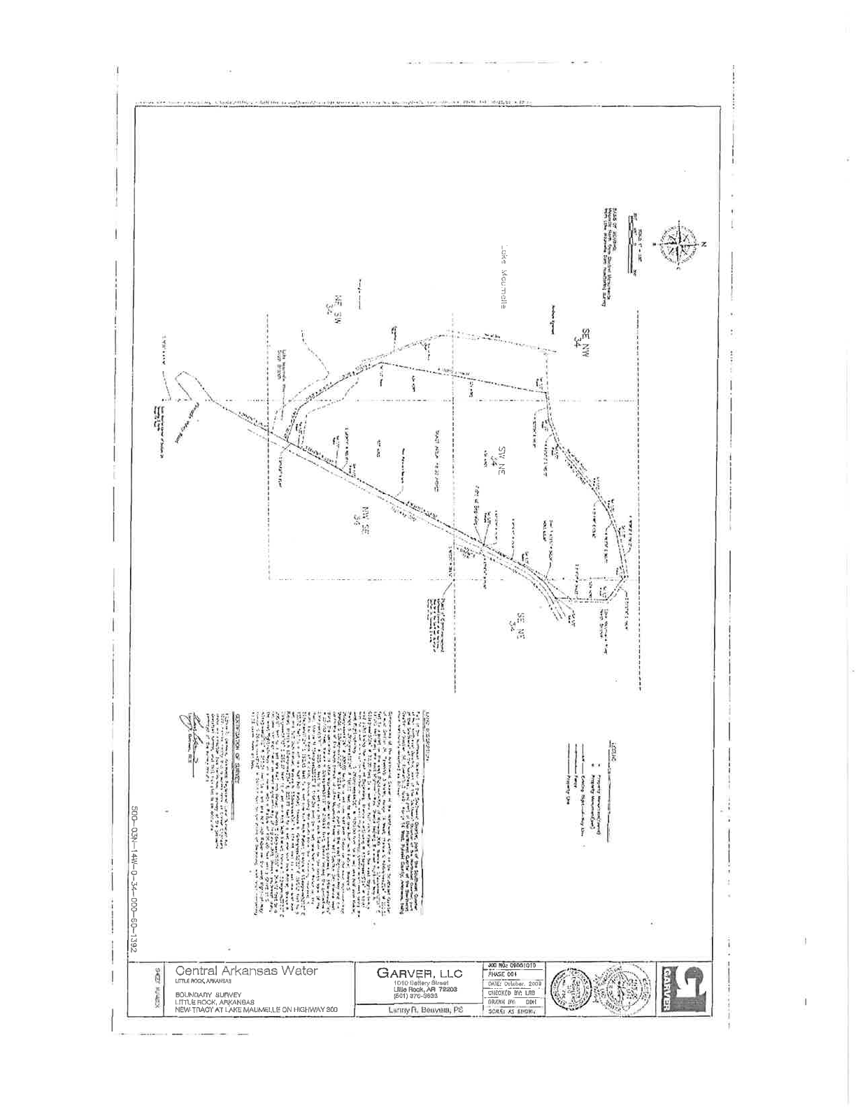
BXHIBIT
A
Description
of
Real ProPertY
The
following
lands situated
in Pulaski
County,
Alkansas:
EXIIIIJIT
A
Description
of
Real ProPerfY
The
following
lands situatecl
irr
Pulaski
Couuty,
Arkansasr
Part
of
the Northeast
Quatter
of the
Southwest
Quafier,
part
of
the Southeast
Quarter
of the
Nortfuwest
Quafier,
part
of
the Sout]rwest
Quafier
of
th<; Noúheast
Quarter,
part
of the Soutlieast
of
the Nor.theast,
ancl
par:t
of
the Northwest
Quar[er
of the
Southeast
Quarlor
of
Section
34,
Township
3
North,
Range 14
West, Pulaslti Coruity,
Adransas,
being more
particularly
clescribecl
as follows:
Comrnencing
at the
Northeast
Conrer of the
Nor{hwest
Quartet'
of the
Soutlieasi
Quarter
of said
Section
34, Township
3
Nolth,
Range
i4
West;
iirence
S Bgcleglees2'26"
W
260'50
f'eet
to
a
poinl
on tlre east
Rìglrt-of-Way
of Hig}way
300; thence N
23degrees52'26t1E
197.80
feet
along
the
east Right-oÊWay;
thence leaving the
east
Right-of Way
N 63degrees15'34"
W 70,00
feet to a
set
one
half
inch
Rebar
on the
west
Riglrfof'-Way
said
point being
the
Poiil of
Bcginning;
thcnce
co¡ti¡uingN
63clegrees15'34"
W
10,00
feet
to a set
onehalf inch
Rebar
on the westRight-of'-
Way;
thencc
southwest along
the
west Right-of-Way
S 26deglees44'26'W
il00'00
leet
to a
set one
half inoh Rebar;
thence S
29degtees36'26t'
W
100
10 fest to
set one
half inch
Rebar;
tlrence
S
26deg:ees 44'26" W 3 00.00
feet
to
a
set
one
half
inch
Rebar on the
west
Right-oÊ'Way;
thence
S
2Sclegroes
10'26u W 92.64
feet
to
a
point on tire west
Right-of:Way
and
the
center'line
of
the
south
branch
of
Little
Maqnelle
River
in said Section
34;
thence west
along
the
centerline
of
Little
Maurnelle
River for
the
following coruses;
N
68c1egrees51'49"
W
257,03
feef;
thence N
32degrees5l'18"
'V7
330.69
fèet;
thence
leaving ,the
centerline N
23degrees55r1
1"
W
325.41
feet
to a set
one half iuch Rebar on
the
North
bank
of
the
river; thence
N 1Odegrees25'55"
E 1196'39
feet to a set
one
half hrch
Rebar
on
the
south
top
of
banl< of
a
ditch; thence
along the
south
bank
tlre followirg
cou(ses; N
B2degreesll.'24"
8192.15 feet lo
a set
one
half
inch
Rebar';
tlience
N
69degrees52'Izu
E 183.72
feet to
a set one
half inch
Rebat'; thettce
N 49clegrees39'32'E
395,63
feet to
a
set one
half
inch Rebar'; thencc
N
55degrees4'56'
E 178.86
f'eet
to
a
set one half
inch
Rebar;
thence N
6Sdcgrees3'34"
E 203,77
feet
to
a set
one
half inch Rebar;
thence
N
TBclegrees56'13"
E
290.27 feet to a set
one
half inch
lìebar; thelce S
52clegtees37'30u
E
208.81'
feet
to a set
one
half inch Rebar;
thence
S 2degleeslB'25"'W
364.92
feetto a set
onehaif
incir
Reba¡ on west
Right-of-Way
of Higirway
300; tirence
southwest along
tlie west
Rigirt-of-Way
on
a
curvs
with
a
Radius
of.626.80 feet
and a Chord of S
43degrees02'1.2"
W
345,54 feet
to a set
ore half
inch
Rebar
on the west
Right-of-Way;
thence
S 26degrees42'42'W
297,67
feet
to the
Point
of Begimring;
said
tract
containing
48,33
acles
rnot'e or less.
I
A
o
:J
I
(/ì
r1
u
o
I
o
h
z
I
s
-f-
o
I
u
t
o
o
I
o
I
u
!Þ
N
Central
Arkansas
Water
ftmq(,Mqs
ÉOUNÖANY SURVF/
LrfLÈ
FOCk, AF,|Ç{NSA8
NÊW.TnACì' AI
LAKE
MAUò/ELLË
ON
TIGHWAY 3ÓO
I
S
&
tr610t0
GRnveR.
u-c
l-¡wm
1o1oo¿llw*sd
I sl& abbe, 2æ¡
-[kRæk.ÀB
7t243 l---:i;-...:---..---
-
il09,ãioli,âf.tn* l-slgcxtü--Bï
.*
OMIH OY ON