Fillable Printable Project Plan
Fillable Printable Project Plan
Project Plan

1
Project Plan
Project Name: Minnesota Geospatial Commons – Test Implementation
Date: 06/07/2010 Version: 1.3
Prepared By: Mark Kotz
A Executive Summary
Business Need/Opportunity
The Minnesota geospatial community has access to a large number of shared geospatial datasets, mainly
through multiple data download sites. However, no one web location exists through which people and
organizations can find and share such data. Shared web services and applications are even less accessible, and
only modestly promoted as a potential shared resource. There exists in Minnesota a significant opportunity to
collaboratively develop a single location through which published Minnesota geospatial resources can be found
and shared.
Many in the community are very interested in this opportunity and have a compelling business need to see it
succeed, not the least of which are the agencies that manage the biggest GIS data distribution sites in the state
(DNR, Met Council, MnGeo & Mn/DOT). Further, the existence of a collaboratively developed Commons
may eliminate the need for existing, disparate GIS data download sites, saving several organizations from the
responsibility of maintaining their own sites and upgrading them periodically.
The coordinated geospatial commons that is envisioned would greatly advance our ability to share web services
in particular, by both providing a place to publish information about them and also by facilitating assessments
of the reliability and trustworthiness of such web services. The increased usage of web services will produce
efficiency gains for many organizations, in particular those that develop geospatial applications.
Perhaps most importantly, the Commons will provide a one stop location for a broad array of business and GIS
users in Minnesota and beyond, whether professional or casual, to find and share useful resources, and will
promote greater sharing of geospatial data, services and applications.
Statement of Work
This effort includes the following:
Define the needed functions of the Commons
o
Begin with those functions needed by the major data producers
o
Get additional input from the broader MN geospatial community
Assess existing sites and products and choose a product for a test bed implementation
Further define the critical functions and requirements (i.e. role of the broker, services documentation)
Form a multi agency implementation team advised by the Commons workgroup
Create and approve a project charter
Create and approve a project plan for the test bed implementation
Implement a test bed Commons focusing on high priority functions
Test functionality and assess strengths and deficiencies of software product and implementation
methods
Make recommendations and project plan for a full production Commons, including
o
Roles and responsibilities
o
Functions to include
o
Implementation methods
o
Timeline

2
o
Governance
Report findings
Seek commitment and/or funding
This effort does not include the following:
Implementing a final production Commons
Project Objectives
Business Objectives for the project are:
Define the needed functions of the Commons
Implement a test bed version of the Commons
Make recommendations and develop a project plan for a full production Commons
Report to MnGeo and the geospatial community
Constraints
The following limitations and constraints have been identified for this project:
The effort relies on voluntary participation by multiple government agencies
This project has no defined budget
This project will proceed within the bounds of the prioritized Commons functional requirements
previously defined by the Geospatial Architecture Workgroup
Upon approval of this Project Charter, the next milestone will be the completion of a Project Plan.
Assumptions
The following assumptions were made when developing this Project Charter:
This project has the approval of MnGeo to host the test bed Commons.
Participating agencies will continue to support staff involvement with this project.
More specific staff commitment levels will be defined in the project plan.
The Project Charter was approved on 3/19/ 2010.
B Scope Overview
Business Scope
Phase 1 – Requirements
Define and prioritize preliminary list of functions
Assess user needs and modify functions and priorities if appropriate
o
Create online survey
o
Advertize on existing data discovery sites and GIS/LIS newsletter
o
Compile results and compare to functions list and modify as appropriate.
Assess web service requirements
o
Clarify what comprises comprehensive documentation of a web service.
o
Agree on a list of key characteristics that must be addressed to achieve “trust” in a web service.
o
Further define the roles of the Broker (both machine and human) and the Enterprise Service
Provider with respect to quality of service and trust.
o
More clearly define the options for, and recommended functions of the broker and how it interfaces
with the service provider and the application client.

3
Phase 2 – Implementation – ESRI Geoportal Extension
Identify a host server
Identify training needs of implementation group
Research functionality and configuration options
Develop a plan for which Commons functions will be implemented
Develop a configuration plan
Define how selected geoportal software will fit into existing architecture
Install and/or configure hardware and firewall connections
Install and configure software
Implement client functions and complete UI/design work
Individual agencies contribute resources (e.g. data, services, applications) to test Commons
Develop a test plan and test cases
Test implemented functions
Assess how implemented functions meet workgroup defined needs
Describe what other functionality is needed
Recommend how that functionality might be acquired or created
Recommend whether the ESRI product should be used for a production site
Modify implementation if appropriate
Phase 3 – Make Recommendations and Plan for Production Commons
Make recommendations for a production Commons
o
Functions to include
o
Implementation strategy
o
Roles and responsibilities
o
Estimated up front and ongoing costs
o
Benefits and risks
o
Potential sources of funding
Articulate the benefits of sharing services and of achieving a system that effectively supports sharing of
services.
Model service level agreements
o
Develop or find a template or model for a service level agreements (SLA).
o
Work toward an SLA for the MnGeo image service.
Report to stakeholder organizations, including participating agencies, MetroGIS Policy Board and the
MN Geospatial Advisory Councils
Report to the MN geospatial community, federal partners, NSGIC and others. They may have valuable
input or assistance.
Propose a project plan for a production Commons
Scope Management Plan
Proposed scope changes will be assessed in terms of impact to project schedule, cost and resource usage.
Any
changes to this scope must be documented in a revised version of the project plan. Approval of Project Manager is
required. Any scope changes involving staffing or funding changes also require the approval of the project owners.
C Budget Overview
Estimated budget for the project by state fiscal year:
Budget Amount: $0 Fiscal Year: 2010 Funded? Yes No
Budget Amount: $0 Fiscal Year: 2011 Funded? Yes No

4
All staff time, hardware, software and other resources will be contributed in-kind from participating organizations.
A request will be made to MetroGIS to fund staffing for some key project tasks.
Budget Management
Any changes to the budget must be documented in a revised project plan. Approval of Project Manager and Project
Owners is required.
D Project Team
The following people and organizations are stakeholders in this project and included in the project planning.
Additional project team members are added as needed.
Executive Sponsors: Commit resources & advocate for project
David Arbeit, Minnesota CGIO, MnGeo
Dave Hinrichs, CIO Metropolitan Council
Kathy Hofstedt, CIO Mn/DOT
Robert Maki, CIO Minnesota DNR
Project Owners: Ensure adequate resources are available and track project status
Chris Cialek; MnGeo
Rick Gelbmann, Metropolitan Council
Tim Loesch, Minnesota DNR
Dan Ross, Mn/DOT
Project Manager: Lead the planning and execution of the project, chair workgroup
Mark Kotz, Metropolitan Council
Project Workgroup: Plan and design the Commons, advise Implementation Workgroup
Mark Kotz, Met. Council (Chair)
Bob Basques, St. Paul
Chris Cialek, MnGeo
Jessica Deegan, Met. Council
Jessica Fendos, DEED
Josh Gumm, Scott County
Leslie Kadish, MN Historical Society
Steve Lime, DNR
Charlie McCarty, Mn/DOT
Chris Pouliot, DNR
Nancy Rader, MnGeo
Nancy Read, Metro Mosquito Control District
Dan Ross, Mn/DOT
Hal Watson, DNR
Paul Weinberger, Mn/DOT
Implementation Team: Implement test bed version of ESRI Geoportal Extension
Jessica Deegan, Met. Council (Co-Team Lead)
Jim Dickerson, MnGeo
Josh Gumm, Scott County
John Harrison, Mn/DOT

5
Susanne Maeder, MnGeo
Chris Pouliot, DNR (Co-Team Lead)
Survey Team: Plan and implement a user survey
Jessica Deegan, Met. Council
Chris Pouliot, DNR
Alison Slaats, 1000 Friends of Minnesota
Service Requirements Team: Identify issues related to web services requirements and how they might be
implemented using a broker in the Commons environment
Hal Watson, DNR (Team Lead)
Jessica Fendos, DEED
Susanne Maeder, MnGeo
Matt McGuire, Met. Council
Project Team Management
The project manager coordinates the project tasks assigned to team members. Changes to the project team require
approval of the Project Manager and Project Owner for the affected agency if relevant. Changes will be tracked in
revisions to the project plan.
E Project Schedule
Key project tasks, responsible groups and estimate hours:
Detailed project schedule is provided below.
Schedule Management
The project Schedule will be posted online and updated as tasks are completed. Any changes to the schedule must
be documented in a revised project schedule. Sign-off from Project Manager is required
6
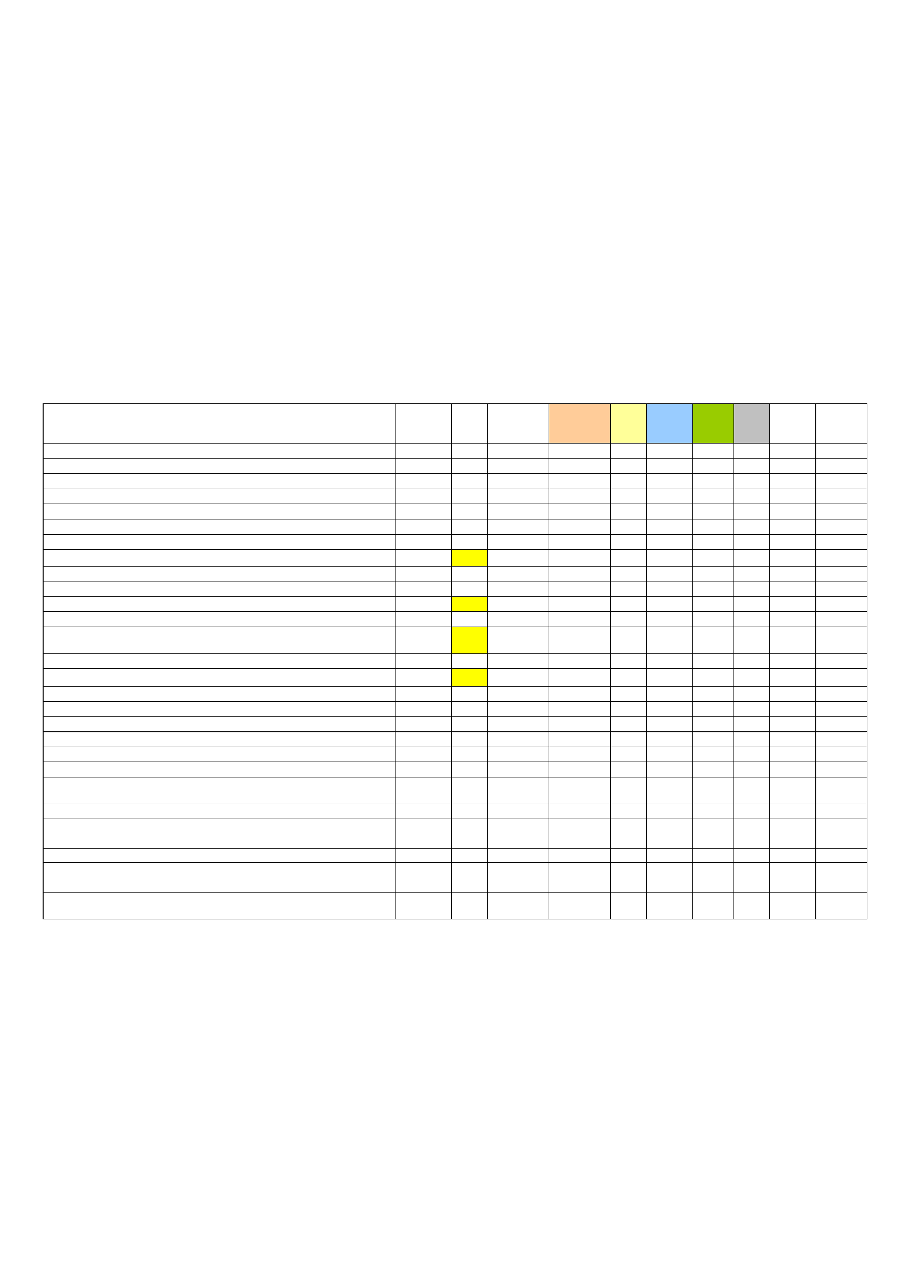
Project Tasks with Estimated Completion Dates and Total Person Hours Required
Task (time estimates to the right are in total person hours for task) Estimated
Complete
Date
Done Resources
if not full team
Implement Work
group
Service
Reqs
Survey Proj
Mngr
MnGeo Sponsors
Preliminary functions defined and prioritized 11/13/09
Workgroup agrees to implement ESRI Geoportal Toolkit as test bed 02/04/10
Approve project charter 03/15/10
Online survey is launched 03/16/10
10
Create draft project plan 03/26/10
5
Draft project plan reviewed by workgroup 04/08/10
8
Research functionality and configuration options 04/29/10
30
Identify training needs (if any) of implementation group. 05/01/10 1 person
2
Project plan approved by workgroup 05/06/10
5
Identify a host server 05/07/10
1
Clarify what comprises comprehensive documentation of a web service 05/14/10
9
Develop plan for which Commons functions will be implemented in test 05/15/10
20
Designate how selected geoportal software & components will fit into
existing architecture
05/15/10 1 person
4
Report on survey results to date and comparison with list of functions 05/21/10
2
Project plan approved by executive sponsors, owners and project manager 05/21/10
3
Develop a configuration plan 06/04/10
20
Install and/or configure hardware and firewall connections 06/11/10 1 person
3
Agree on a key characteristics to achieve “trust” in a web service 06/18/10
9
Install and configure software (including toolkit and underlying software) 06/25/10 1 person
20
Online survey is ended 06/30/10
0
Compile survey results and compare to functions list 07/09/10
4
Define roles of Broker (machine & human) and Provider relate to quality
of service & trust
07/15/10
12
Develop a test plan, test cases, and tracability matrix 07/16/10
10
Define options for, and recommended functions of broker and how it
interfaces with service provider and the application client
08/06/10 2 people
20
Submit MetroGIS funding proposal if appropriate. Due Sept. 2
nd
.
Implement client functions and complete UI/design work. (tasks broken
down by functionality pieces eventually)
09/17/10
?
Individual agencies contribute resources (e.g. data, services, applications)
to test Commons
09/24/10
15

7
Test implemented functions 09/24/10
15
Revise any needed implementation pieces 10/01/10
?
Revise data or service contributions 10/07/10
6
Test Bed running with real data & services - open for comments 10/11/10
?
Give presentation about Commons at MN GIS/LIS Consortium Conference 10/15/10
5
Assess how implemented functions meet workgroup defined needs 11/04/10
10
Describe what other functionality is needed 11/04/10
10
Modify implementation if appropriate, based on feedback 12/02/10
?
Recommend how that functionality might be acquired or created 12/02/10
?
Recommend whether the ESRI product should be used for a production site 12/02/10
?
Create draft recommendations for a production Commons 12/16/10
8
Modify and approve recommendations for a production Commons 01/06/11
?
Create draft project plan for a productions commons 01/20/11
10
Modify and approve project plan for a production commons 02/03/11
?
Report to stakeholder organizations and geospatial community 02/11/11
?
Model service level agreements 02/11/11 2 people
8
Articulate the benefits of sharing services and a system that supports such
sharing
02/11/11
?
109+ 69+ 58 16 28 1 3

8
F Communication Plan
The Geospatial Commons Workgroup will maintain a schedule of monthly meetings. All workgroup members,
subgroup members, project owners and other who have expressed interest are included in the CC list for meeting
agendas and meeting notes. If a particular meeting is not needed, it will be cancelled. The workgroup maintains a
Basecamp web site for collaborative work. This site is accessible only to authorized users. Additional or alternate
workgroup collaborative work sites will be considered if the need arises.
The workgroup chair/project manager will report progress to the following groups at their request:
MetroGIS Coordinating Committee
MetroGIS Policy Board
State Government Geospatial Advisory Council
State Agency Geospatial Advisory Council
Key stakeholder organizations will be kept abreast of the progress of the workgroup through their representatives
on the workgroup.
The workgroup will also maintain a web page under the MnGeo advisory committee site at
http://www.mngeo.state.mn.us/workgroup/commons/index.html. The project schedule will be updated periodically
and posted on this site.
It is expected that workgroup members will provide presentations about the project at various venues. Specifically,
the project will be presented at the Minnesota GIS/LIS Conference in October.
Individual task teams will work closely on a weekly or daily basis while completing specific tasks.
G Issues Management
As issues arise within the project, each team will determine if the issue is significant enough to report it to the
Project Manager. The Project Manager, in consultation with the Team Lead, will decide if the issue should be
reported to the full Workgroup. If so, the collaborative work site will be used as a place to describe and track
issues. For project work to continue efficiently, it is desirable that most issues be resolved within each team or with
consultation with the Project Manager. Issues may include testing results, unexpected problems, and other items
that impact project completion.
H Project Plan Documents Summary
All significant electronic project documentation will be posted on the collaborative work site. Teams will
determine when a document is sufficiently complete to post on the site.

9
I Approval
Below is documentation of confirmation that project sponsors, project owners and project manager have
reviewed the information contained in this document and approve of this as the formal project plan for the
Minnesota Geospatial Commons – Test Implementation project.
To indicate approval, send an email to mar[email protected]n.us stating that that you approve the project plan
for the Commons Test Implementation project.
Executive Sponsors: Commit resources & advocate for project
David Arbeit, Minnesota CGIO, MnGeo
Dave Hinrichs, CIO Metropolitan Council
Kathy Hofstedt, CIO Mn/DOT – Approved by email 5/21/10
Robert Maki, CIO Minnesota DNR – Approved by email 5/25/2010
Project Owners: Ensure adequate resources are available and track project status
Chris Cialek; MnGeo
Rick Gelbmann, Metropolitan Council – Approved by email 5/12/10
Tim Loesch, Minnesota DNR – Approved by email 5/19/10
Dan Ross, Mn/DOT – Approved by email 5/20/10
Project Manager: Lead the planning and execution of the project, chair workgroup
Mark Kotz, Metropolitan Council – Approved 5/10/10